 |
| Image: PAGASA |
July 25, 2023 (11:00 am) - Super Typhoon "Egay" maintains its strength as it poses a serious threat to the northern provinces of Luzon. The Philippine Atmospheric, Geophysical, and Astronomical Services Administration (PAGASA) has issued storm signals and provided crucial information to help the public prepare for the impact of the typhoon.
Hazardous Rainfall Outlook
PAGASA predicts heavy rainfall for various areas in Luzon. The accumulated rainfall forecast from today until tomorrow noon is as follows:
Above 200 mm:
- Northern portion of mainland Cagayan, including Babuyan Islands
- Batanes
- Ilocos Norte
- Ilocos Sur
100-200 mm:
- Northern portion of La Union
- Western portion of Kalinga
50-100 mm:
- Isabela
- Northern portion of Zambales
- Rest of Ilocos Region
- Cordillera Administrative Region
The forecast for tomorrow noon until Thursday noon is as follows:
Above 200 mm:
- Babuyan Islands
- Ilocos Norte
- Northern portions of Abra and Ilocos Sur
100-200 mm:
- Batanes
- Northwestern portions of mainland Cagayan
- Northern portion of Apayao
- Rest of Abra and Ilocos Sur
50-100 mm:
- Benguet
- La Union
- Pangasinan
- Western portions of Kalinga and Mountain Province
- Rest of Apayao
The forecast for Thursday noon until Thursday evening is as follows:
50-100 mm:
- Batanes
Floods and rain-induced landslides are highly likely, especially in areas susceptible to these hazards and regions experiencing considerable rainfall in recent days. The Southwest Monsoon, enhanced by Super Typhoon "Egay," will continue to bring occasional to monsoon rains over western portions of Central Luzon, Southern Luzon, and Visayas for the next three days.
Severe Winds
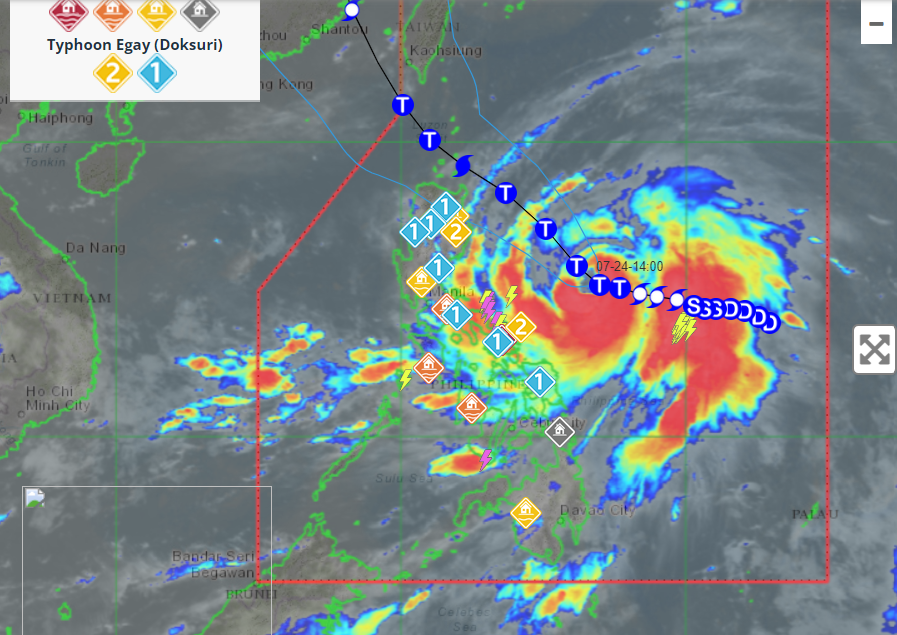
PAGASA has issued various Tropical Cyclone Wind Signals (TCWS) based on the intensity of the winds. Locations under Wind Signal No. 4, which indicates the highest wind threat, are:
- Luzon: The northeastern portion of mainland Cagayan (Santa Ana)
Locations under Wind Signal No. 3, which indicates a very intense typhoon affecting the area, include:
- Luzon: Babuyan Islands, the northern and eastern portions of mainland Cagayan, the northeastern portion of Isabela, and the northern portion of Apayao
Locations under Wind Signal No. 2, which indicates strong winds, are:
- Luzon: Batanes, the rest of mainland Cagayan, the rest of Isabela, Quirino, the northern portion of Nueva Vizcaya, the rest of Apayao, Kalinga, Abra, Mountain Province, Ifugao, the northern portion of Benguet, Ilocos Norte, Ilocos Sur, and the northern and central portion of Aurora
Locations under Wind Signal No. 1, which indicates moderate winds, are:
- Luzon: La Union, Pangasinan, the rest of Benguet, the rest of Nueva Vizcaya, the rest of Aurora, Zambales, Bataan, Nueva Ecija, Tarlac, Pampanga, Bulacan, Metro Manila, Rizal, Laguna, Cavite, Batangas, Quezon, Marinduque, Camarines Norte, Camarines Sur, Catanduanes, Albay, Sorsogon, Burias Island, and Ticao Island
Coastal Inundation
There is a high risk of storm surge affecting the low-lying and exposed coastal areas of Batanes, Cagayan including Babuyan Islands, Isabela, and Ilocos Norte. Storm surge heights may exceed 3.0 meters in some warning areas.
Hazardous Conditions at Sea
Under the influence of Super Typhoon "Egay," a Gale Warning is in effect over several coastal waters along the seaboards of Luzon, Visayas, and Northeastern Mindanao. Sea travel is risky for most vessels, and all mariners are advised to remain in port or seek safe harbor until winds and waves subside.
Forecast Track and Intensity
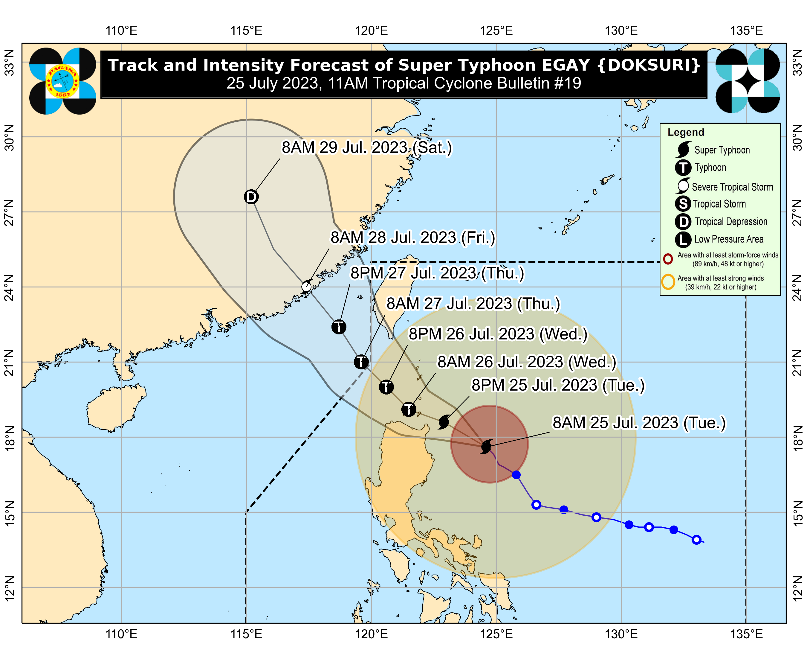
Super Typhoon "Egay" is forecast to move northwestward in the next 12 hours before turning generally west-northwestward and crossing the Luzon Strait. It is expected to make landfall or pass very close to Babuyan Islands and the northeastern mainland Cagayan area between late evening today and tomorrow morning.
After passing the Babuyan Islands, "Egay" will turn northwestward or north-northwestward, passing over the waters south of Taiwan. It is forecast to exit the Philippine Area of Responsibility on Thursday morning, crossing the Taiwan Strait, and making landfall in the vicinity of Fujian, China, on Friday morning.
The typhoon is nearing its peak intensity, with a short window for potential slight intensification in the next 12 hours. Afterward, a weakening trend is expected due to interaction with the rugged terrain of Northern Luzon and Taiwan. Further weakening is expected as it moves outside the PAR region and approaches China's landmass.
Current Location and Strength
As of 11:00 am on July 25, 2023, the center of the eye of Super Typhoon "Egay" was estimated at 270 km East of Tuguegarao City, Cagayan. It is moving northwestward at a speed of 15 km/h, with maximum sustained winds of 185 km/h near the center and gustiness of up to 230 km/h.
Forecast Positions
PAGASA has provided forecast positions for the typhoon:
- Jul 25, 2023, 08:00 PM - 135 km East Northeast of Aparri, Cagayan
- Jul 26, 2023, 08:00 AM - Over the coastal waters of Calayan, Cagayan
- Jul 26, 2023, 08:00 PM - 120 km Northwest of Calayan, Cagayan
- Jul 27, 2023, 08:00 AM - 235 km West of Itbayat, Batanes (OUTSIDE PAR)
- Jul 27, 2023, 08:00 PM - 370 km West Northwest of Itbayat, Batanes (OUTSIDE PAR)
- Jul 28, 2023, 08:00 AM - 580 km Northwest of Itbayat, Batanes (OUTSIDE PAR)
- Jul 29, 2023, 08:00 AM - 1,015 km Northwest of Extreme Northern Luzon or in the vicinity of Jiangxi, China (OUTSIDE PAR)
Precautionary Measures
Given the severity of Super Typhoon "Egay," residents in the affected areas are strongly advised to take precautionary measures and heed the official advisories and warnings issued by PAGASA and local disaster response agencies. Preparedness and safety should be the utmost priority to minimize the potential impact of this powerful typhoon.


