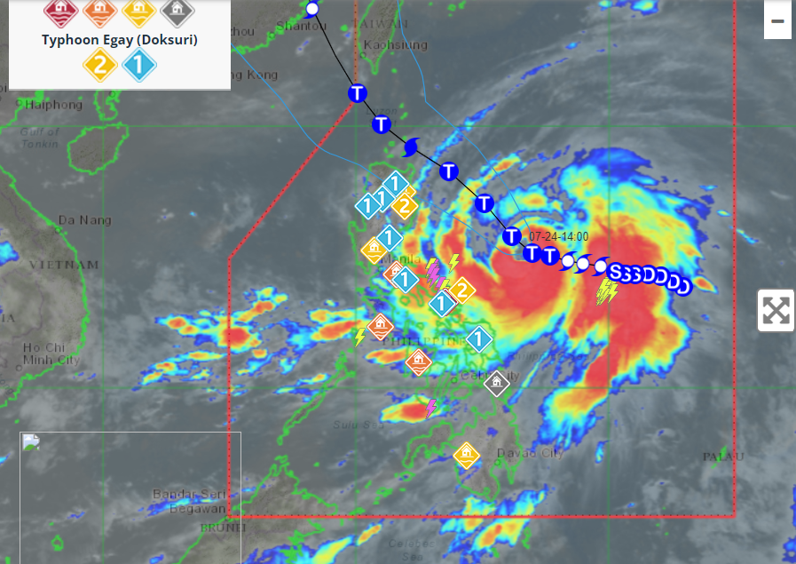
In its latest bulletin, the Philippine Atmospheric, Geophysical, and Astronomical Services Administration (Pagasa) reported that Tropical Storm "Egay" (International Name "Doksuri") has slightly intensified while moving west over the Philippine Sea. As of the 5 p.m. update on Saturday, the storm's center was estimated to be about 685 kilometers east of Virac, Catanduanes, with maximum sustained winds of 75 kilometers per hour (kph) near the center and gustiness of up to 90 kph. Pagasa forecasts that "Egay" will further intensify into a severe tropical storm within the next 12 hours. Moreover, there is a possibility that the cyclone could reach super typhoon category by Tuesday or Wednesday while over the Philippine Sea east of Extreme Northern Luzon.
As of the current update, no wind signals have been raised. However, the enhanced southwest monsoon could bring occasional rains over Western Visayas and Occidental Mindoro. In response to this situation, Pagasa is considering issuing a weather advisory for these areas in anticipation of potential heavy rainfall, which may lead to flooding and rain-induced landslides, particularly in highly susceptible regions identified in hazard maps and areas that have experienced significant rainfall in recent days. Additionally, gusty winds are expected over certain parts of Visayas, Northern Mindanao, and selected provinces.
Tropical Cyclone "Egay" (Doksuri) Updates and Intensification
At present, Tropical Storm "Egay" (Doksuri) is located at approximately 685 kilometers east of Virac, Catanduanes. The storm's current maximum sustained winds are reported to be 75 kph near its center, with gustiness reaching up to 90 kph. The cyclone is anticipated to intensify further and transform into a severe tropical storm within the next 12 hours.
Pagasa's forecast for the subsequent period indicates that Tropical Storm "Egay" will steadily intensify as it moves westward. The cyclone may potentially escalate to a super typhoon category by Tuesday or Wednesday, while situated over the Philippine Sea east of Extreme Northern Luzon. This progression indicates a significant threat and calls for vigilant monitoring of the storm's developments.
Potential Impacts of Tropical Storm "Egay"
As of the current update, Pagasa has not yet raised any wind signals. Nevertheless, the enhanced southwest monsoon brought about by the storm could result in occasional rains over Western Visayas and Occidental Mindoro.
In light of these conditions, Pagasa is considering issuing a weather advisory for the affected areas to alert residents and authorities about the possibility of heavy rainfall. Areas identified as highly or very highly susceptible to hazards, as indicated in hazard maps, are at increased risk of flooding and rain-induced landslides. Furthermore, localities that have recently experienced substantial amounts of rainfall are particularly vulnerable and should exercise caution.
Gusty winds are also expected in certain regions, including the western and southern portions of the Visayas, the northern portions of Northern Mindanao, and specific provinces such as Caraga, Romblon, and Masbate. Residents in these areas should take necessary precautions to mitigate potential damage and ensure their safety.
The Role of Enhanced Southwest Monsoon
The enhanced southwest monsoon, also known as the "Habagat" in the Philippines, plays a crucial role in the country's weather patterns during the monsoon season. The monsoon is characterized by moist air masses coming from the southwest, colliding with warm air over land areas. This interaction leads to the development of convective storms and widespread rainfall in affected regions.
During the monsoon season, the southwest monsoon is responsible for bringing rainfall to the western side of the Philippines. It is essential to closely monitor the monsoon's behavior as it can interact with tropical cyclones, such as Tropical Storm "Egay," resulting in increased rainfall and potential hazards like flooding and landslides.
Conclusion
Tropical Storm "Egay" (Doksuri) has intensified slightly as it moves westward over the Philippine Sea. The cyclone's proximity to land and its projected intensification into a severe tropical storm and possibly a super typhoon call for heightened monitoring and preparedness in affected regions.
While no wind signals have been raised at the moment, the enhanced southwest monsoon could bring occasional rains to Western Visayas and Occidental Mindoro. As a result, Pagasa is considering issuing a weather advisory for these areas, warning residents about the possibility of heavy rainfall and its associated risks.
To ensure the safety of communities, particularly those identified as highly susceptible to hazards, it is vital for authorities and residents to remain vigilant and take necessary precautions. As Tropical Storm "Egay" progresses, continuous monitoring and dissemination of accurate information will be crucial in effectively managing its impacts and safeguarding lives and property.


No comments:
Post a Comment